Geospatial Analysis.
Geospatial data, which is also reffered to as geodata usually consists of locational information connected to a dataset. For instance address, city or ZIP code. Geospatial data can also come from Global Positioning System (GPS) data, geospatial satellite imagery, telematics devices, IoT and geotagging
Brief History of Geospatial
8th of February 2005 was the year that Google Maps was launched in the US, which made mapping technology easily accessible to the general Public. It has since then revolutionised the world of digital maps.
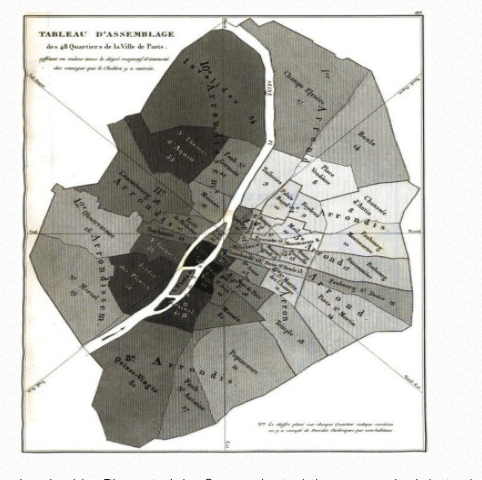
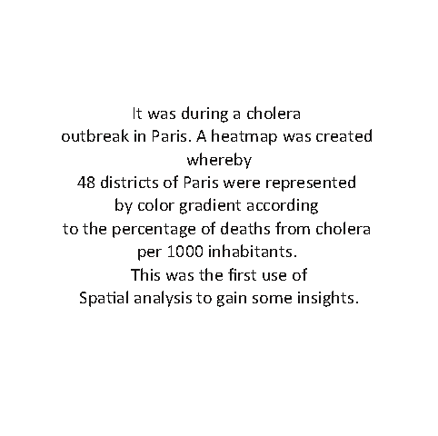
But the first spark of geospatial technology was ignited in 1832 by French cartographer Charles Picquet.
| heatmap by Charles Picquet | …. |
|---|---|
 |
 |
In the early 1850s, photozincography or as heliozincography was developed at the Ordnance Survey out of a need to reduce large-scale maps more effectively. It was a form of map printing with separate layers. Each layer could visually represent data on the map.
In the year 1963 Roger Tomlinson coined the term geographic information system (GIS), which he was the pioneer. This was a system that was designed to capture, store, manipulate, analyze, manage and present all the types of geographical data. Which were a form of table maps.
GIS was further refined from the earlier on table maps to what we have today as dynamic and interactive maps. Since then, geospatial technology has evolved from the desktop to a cloud-based system. The user-friendly and open source software versions that have come to be, has been the key to ease of accessibility to the public.
Back to Civilization!
In our research we are interested in using spatial analytics methods to visualize the distribution of social amenities in Kenya i.e Universities & colleges, Schools(primary and secondary), Hospitals and the like. Visualization of the universities in Kenya. code to reproduce the map can be found HERE!! and the notebook HERE!! To show the name of a university one can click on the blue markers.